

Pinnacles National Park is simultaneously underrated and overpopulated. In comparison to other California parks, like Yosemite and Joshua Tree, many people claim Pinnacles is “underwhelming” since it’s a small park with a limited number of things to do.
Yet it is also very busy due to its proximity to San Jose and San Francisco. That said, Pinnacles National Park has some wonderful hiking trails for a weekend getaway or day trip.
If you look at the hiking trails in Pinnacles National Park on Alltrails or the NPS website, it looks like there are a ton of hiking trails. But this is a bit of an illusion. There are really only a handful of places to hike to, but each of them can be accessed from each of the various parking lots, giving the impression that there are lots of hiking trails.
In this guide, I’ll go over the best Pinnacles hiking trail which visits all of the best features in the park. I’ll also go over all of the shorter trails you can use to access the sights if you don’t want to hike the full trail.
Finally, I’ve included some tips and answers to FAQs at the end to ensure you have the best experience at the park!

This post may contain affiliate links. If you make a purchase through one of these links, I may receive a small commission at no extra cost to you. Your support is much appreciated! You can learn more by reading my full disclosure.
The Best Pinnacles Hiking Trail
True to its name, the Greatest Hits is an amazing trail and hits all of the best parts of Pinnacles National Park. I’m going to go over this trail in detail, specifically highlighting each of the features.
The full trail is 12 miles with 3000 feet of elevation gain, so if you don’t want to do the full loop, there are shorter trails that each hit one or two of the features. I’ve linked to the shorter trails throughout this section.
If you don’t have time for the full hike, my next top recommendation is Condor Gulch to High Peaks Loop, which visits everything except the Balconies Cliffs and is 3 miles shorter.
Starting at Bear Gulch Day Use Area
You can technically reach the trail from any of the parking lots, using connector trails to reach the main loop. Chalone is a common parking lot because it has direct access to the trail. However, I recommend beginning at Bear Gulch Day Use Area on the eastern side of the park, so you can access the best features earlier in the hike (ideal if you want to catch nice morning light).
Tip: The parking lot fills up quickly, so ensure you get there early – and that means before 8 am on a weekend!
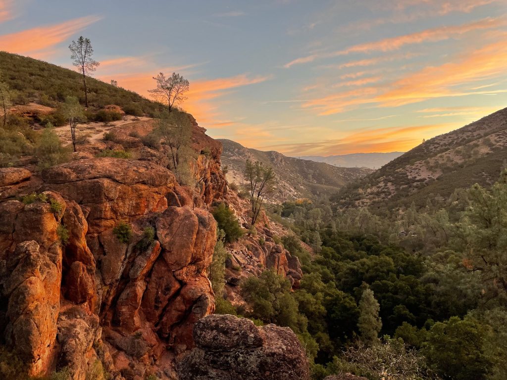
It’s a loop trail and you can either do it clockwise or counterclockwise. I did it clockwise as the sun was rising and it was absolutely beautiful (and not busy at all).
The first part of the hike has low elevation gain and is very straightforward. After half a mile or so you’ll come to a fork in the trail, directing you to either Bear Gulch Reservoir or High Peaks. If you choose to go towards Bear Gulch Reservoir, you can either take the Spring Moses Trail or go through the Bear Gulch Caves.
Bear Gulch Caves
The detour to Bear Gulch Reservoir is 0.8 miles and you can either take the Moses Springs Trail or the Lower Caves Trail.
I chose the caves, though I’ve also taken the other trail (which is great for seeing rock climbers in the afternoon). Going through the caves requires a flashlight and some tight squeezing in places. The rock ceiling is low in some parts, so ducking is required. There are a few steep sections that have railings to help you.
The Lower Caves are open for the better part of the year, though they are periodically closed (especially if there’s been heavy rain recently, as the cave is prone to flooding). The Upper Caves are only open for a few weeks of the year and unfortunately weren’t open when I was there. You can check the current closures here.


Bear Gulch Reservoir
After exiting the caves and climbing a steep, rocky staircase, you’ll arrive at Bear Gulch Reservoir. The reservoir is the only body of water in the park (except when the caves flood) and is a beautiful little spot to take a break. There’s a monolith adjacent to the reservoir, which is a photographers’ delight. I bet it looks great at sunrise or as the foreground for some astrophotography.
Note: Swimming is not allowed in the reservoir (and you definitely wouldn’t want to) and it’s not a water source either. Even with a water filter/purification tablet, don’t drink the water. Pack enough water for your whole hike.

High Peaks
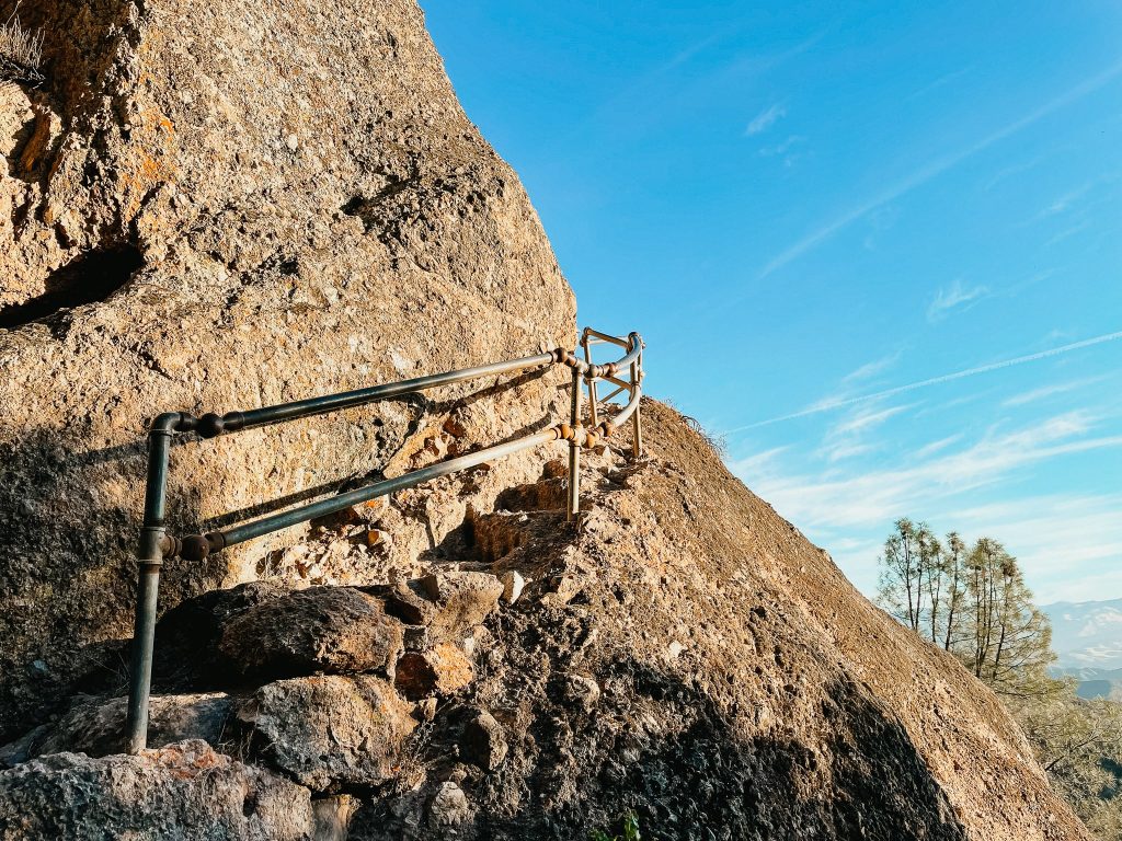
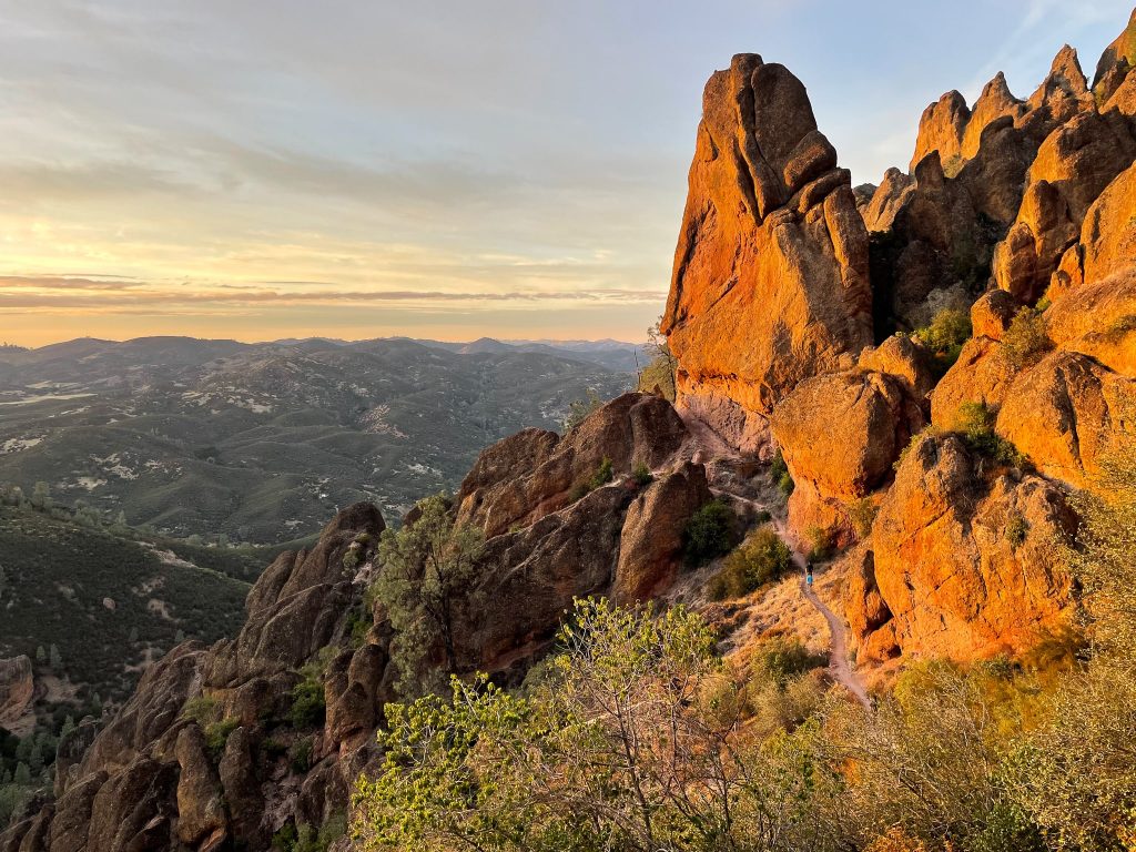
After the detour, the trail meets back up with the High Peaks Trail and this is where things start to get interesting. You will start to see beautiful views of High Peaks, which look beautiful in the morning light. After a mile or so, you’ll be up in the High Peaks.
Here the trail narrows and becomes steep. There are several places where you need to hold on to a railing to climb the steep and narrow rocks. Not for the faint of heart but a lot of fun!
From High Peaks, you can either go to Condor Gulch or take the Juniper Canyon Trail down to the West Pinnacles parking lot. For this particular day, I went directly from High Peaks to Condor Gulch and returned to the Juniper Canyon Trail for sunset. I’ve detailed both options below.

Balconies Cliffs-Caves
If you want to check out the Balconies Cliffs-Caves, you’ll hike down the Juniper Canyon Trail, almost to the West Pinnacles parking lot. At the trailhead, you’ll switch from the Juniper Canyon Trail to the Balconies Cliffs-Caves Trail.
Getting to the trailhead is almost 2 miles of downhill hiking. From there, the Balconies Caves are 1.2 miles away. Keep in mind the caves close periodically throughout the year. You can check the current closures here.
After the Balconies Caves, there isn’t another notable feature for almost 7 miles (besides passing through the Chalone parking lot). The trail is nice, but if you’re short on time I’d recommend going straight from High Peaks to Condor Gulch, as described in the next section.

Condor Gulch Lookout
From High Peaks, the next section of the trail is wider and flatter as you gradually descend to Condor Gulch Lookout. From Balconies, the trail is also wide but gradually ascends from the Charone parking lot.
By the time I got to this section, it was 10 am and there were quite a few other people on the trail. The Condor Gulch Lookout is visually appealing, but by no means spectacular after everything you’ve just hiked. I don’t know if it was the time of day or the sound of people, but there were absolutely no condors here when I visited.
I returned to High Peaks in the late afternoon. Below is a photo of condors from High Peaks as the sun was setting. There were tons of Condors flying around at this time. So if you’re keen to see condors, I recommend doing the Juniper Canyon trail in the late afternoon.

Back to Bear Gulch Wilderness Area
After Condor Gulch, there is a gradual descent to the Bear Gulch parking lot. By midday, it was notably busier and cars were struggling to find parking spots.
Shorter Pinnacles Hiking Trails
In this section, I’ll go over all of the shorter hiking trails that go directly from parking lots to specific features. If you don’t have time or energy to do the whole Greatest Hits loop, piece a few of these together and see your favourite spots!
Trails from Bear Gulch Day Use Area
Moses Spring to Rim Trail Loop
- Type: Out & Back
- Distance: 2.2 miles each way
- Length: 1-1.5 hours
- Elevation Gain: 500 ft
- Difficulty: Moderate
- Link to AllTrails: Moses Spring to Rim Trail Loop
This trail takes you from Bear Gulch Day Use Area to Bear Gulch Reservoir. Depending on which fork you take in the trail, you’ll either stay on a path along the ridge or you’ll go through the Bear Gulch Caves.
The turn for the caves is obvious; there is a sign. There’s also a sign reminding everything that flashlights are recommended when going through the caves.

Condor Gulch to High Peaks Loop
- Type: Loop
- Distance: 5.3 miles each way
- Length: 3-5 hours
- Elevation Gain: 1,300 ft
- Difficulty: Difficult
- Link to AllTrails: Condor Gulch to High Peaks Loop
This is my favourite Pinnacles hiking trail if you can’t do the Greatest Hits. This trail visits both Condor Gulch (there the lookout for condors is), High Peaks, the Bear Gulch Caves and Bear Gulch Reservoir. As I mentioned above, the section around High Peaks is a little tricky because you need to navigate some steep, narrow ridges. There are usually railings, though I wouldn’t recommend this trail to anyone with a fear of heights. Personally, this was my favourite section of the trail because I loved the steep and narrow parts.
High Peaks to Gulch Loop
- Type: Out & Back
- Distance: 6.7 miles each way
- Length: 4-5 hours
- Elevation Gain: 1,425 ft
- Difficulty: Difficult
- Link to AllTrails: High Peaks to Gulch Loop
The only difference between this trail and the one above is that this one goes down to Chalone Creek rather than going to Condor Gulch. If you’re only able to get a parking spot at the Chalone parking lot, then this trail could be a good option.
Otherwise, I’d recommend sticking to the one above. This trail is almost 1.5 miles longer and isn’t a particularly interesting section of hiking.
Carlone Peak Trail
- Type: Loop
- Distance: 9 miles round trip
- Length: 3-5 hours
- Elevation Gain: 2,040 ft
- Difficulty: Difficult
- Link to AllTrails: Carlone Peak Trail
If you reach Bear Gulch Reservoir and think “I am not nearly sweaty enough”, well then I have good news for you. Rather than turning around or connecting to the High Peaks loop, you can take the Carlone Peak Trail to the top of Carlone Peak.
It’s a 3 mile hike each way with a whole lot of elevation gain, but you do get a nice view from the peak (apparently, as I have done this part of the trail yet).
Condor Gulch Trail
- Type: Out & Back
- Distance: 1.7 miles each way
- Length: 1-1.5 hours
- Elevation Gain: 1,100 ft
- Difficulty: Moderate-Difficult
- Link to AllTrails:
This is the route you take if you only want to see the Condor Gulch View Point. Honestly, I wouldn’t recommend doing just this loop (it is one of my least favourite sections of all of the hiking I have done in Pinnacles National Park).

Pinnacles Hiking Trails from Campground
As I said above, AllTrails and the National Parks Service website make it look like there are tons of trails in the Pinnacles.
If you’re camping at Pinnacles, you don’t need to worry about finding parking at the other trailheads, since you can access the other trailheads via short, flat trails adjacent to the road.
Visitor Centre to Bear Gulch Area
- Type: Out & Back
- Distance: 2.3 miles each way
- Length: 1-1.5 hours
- Elevation Gain: 300 ft
- Difficulty: Easy
This is the connector trail between the Visitor Center / Campground and the Bear Gulch Day Use Area parking lot. Recall from above that if you want to hike to Bear Gulch Reservoir, Bear Gulch Caves or Condor Gulch, you’ll likely want to start at the Bear Gulch Day Use Area parking lot. The trail is adjacent to the road (more like a wilderness sidewalk, than a trail).
South Wilderness Trail
- Type: Loop
- Distance: 6.5 miles round trip
- Length: 3-4 hours
- Elevation Gain: 0 ft
- Difficulty: Moderate
- Link to AllTrails: South Wilderness Trail
I’ll only speak briefly about the South Wilderness Trail because I don’t recommend doing this hike. From the Visitor Center, it goes south to the park boundary and then just ends. The route is very flat, but you don’t see any of the features that make Pinnacles National Park so interesting.
Old Pinnacles Trail to Balconies Cave
- Type: Loop
- Distance: 5.3 miles round trip
- Length: 3-5 hours
- Elevation Gain: 0 ft
- Difficulty: Moderate
- Link to AllTrails: Chalone Creek to Balconies Caves
Most people who want to hike to Balconies Cave begin on the west side of Pinnacles National Park, since Balconies Cave is only 2.4 miles from that trailhead. If you’re camping on the east side of the park, however, you can reach the Balconies Caves with this trail.
From the Visitor Center / Pinnacles Campground, there is another trail / wilderness sidewalk called the Bench Trail which goes to the Chalone Creek parking lot. Alternatively, you can park at Chalone Creek and start the trail from here.
Starting at Chalone Creek, take the Old Pinnacles Trail to the Balconies Caves, which is about 3 miles. Once you’re done at the caves, you can either return via the Old Pinnacle Trail (the way you came) or take the Balconies Trail to West Pinnacles and do a whole loop of the park (12 miles in total).

Pinnacles Hiking Trails from West Pinnacles
Balconies Cliffs-Cave Loop
- Type: Loop
- Distance: 2.4 miles round trip
- Length: 1-1.5 hours
- Elevation Gain: 100 ft
- Difficulty: Easy-Moderate
- Link to AllTrails: West Pinnacles to Balconies Cliffs-Caves
This is the trail that goes from the West Pinnacles parking lot to the Balconies Cliffs / Caves and back. Ensure you check the park website for cave closures (linked above).
High Peaks to Balconies Cave Loop
- Type: Loop
- Distance: 8.4 miles round trip
- Length: 4-5 hours
- Elevation Gain: 1,540 ft
- Difficulty: Strenuous
- Link to AllTrails: High Peaks and Balconies Loop
This trail basically combines the Balconies Cliffs-Caves Loop and Juniper Canyon trails to make one huge loop wherein you can see both the caves and High Peaks. It’s very similar to the Greatest Hits trail except that it skips the Bear Gulch Reservoir / Caves and Condor Gulch.

North Wilderness Trail Loop
- Type: Loop
- Distance: 9.3 miles round trip
- Length: 5-8 hours
- Elevation Gain: 1,020 ft
- Difficulty: Difficult
- Link to AllTrails: North Wilderness Loop
The North Wilderness Loop isn’t as popular as a lot of the other trails because it’s quite long and doesn’t go to any of the classic features of Pinnacles National Park, besides the Balconies Caves. So if you’re short on time, I’d recommend either the Greatest Hits or the Bear Gulch – High Peaks loops instead.
On the other hand, if you have more time to spend in the park and would like to get away from the crowds, this could be a great trail for you. Going clockwise, the first two miles have some elevation gain followed by a mile of descending. From there on the trail is mostly flat.
Juniper Canyon Loop
- Type: Out & Back
- Distance: 4.3 miles round trip
- Length: 2-3 hours
- Elevation Gain: 1,215 ft
- Difficulty: Difficult
- Link to AllTrails: Juniper Canyon to High Peaks
The Juniper Canyon trail is how you can access High Peaks (and the other trails) from the west side of Pinnacles National Park. The trailhead is at the Chaparral parking lot.
The trail starts out fairly easy, going through a forested area. About 0.6 miles in, however, the elevation gain starts to pick up. Between mile 2 and mile 3 the elevation increases a bit more. It’s a little tiring, but there were kids around me easily doing the trail so it’s definitely manageable
Prewett Point Trail
- Type: Loop
- Distance: 0.9 miles round trip
- Length: 0.5-1 hours
- Elevation Gain: 70 ft
- Difficulty: Easy
- Link to Hiking Project: Prewett Point
This short Pinnacles hiking trail begins at the West Pinnacles Visitors Center to Prewett Point. From here, you can see views of the High Peaks. I imagine this would be a great place for some astrophotography. Since the trail is very short, it would be good for super novice hikers or those wanting a quick viewpoint before heading deeper into the park. However, I think the views are better from the trails above so I didn’t spend much time here.
Jawbone Trail
- Type: Out & Back
- Distance: 1.2 miles round trip
- Length: 0.5-1 hours
- Elevation Gain: 560 ft
- Difficulty: Easy
- Link to AllTrails: Jawbone Trail
The Jawbone Trail goes to the same lookout as the Prewett Point Trail, but starts at the Chaparrel Overflow parking lot instead of the West Pinnacles Visitor Center.

FAQs about Pinnacles National Park Hiking
How difficult is it to get parking in Pinnacles National Park?
You may have heard that Pinnalces National Park is incredibly busy and the parking lots fill up quickly. This is definitely true. I arrived at the park at 6:45 am and I was the fourth car in the Bear Gulch Day Use Area parking lot. By 10 am, the lots were entirely full and cars were circling the parking lot asking if anyone was leaving.
After I left Bear Gulch, I drove 1.5 hours to the other side of the park (I wanted to be on the east side for sunrise and the west side for sunset). I arrived at the Chaparral parking lot at 4 pm and there were plenty of free parking spots.
As cliche as it sounds to say, if you want to get parking at Pinnacles National Park, you need to arrive either really early (before 8 am) or late (after 4 pm).

Should you park at the West side or East side?
Pinnacles is a small national park and there is a short absolute distance between the two sides of the park. Some of the longer Pinnacles hiking trails mentioned above connect the two entrances. However there are no roads connecting the two sides, so it takes 1.5 hours to drive between them.
I’ve started at both sides of the park. Generally speaking, I think it makes more sense to start on the East side of the park. This puts you closer to Bear Gulch Reservoir and caves and Condor Gulch. High Peaks is about equal distance between the two sides of the park. If you want to visit the Balconies cliffs and caves, then you should start on the West side.
That said, if you’re up for a long hike, the Greatest Hits (listed above) will allow you to hit all of the top features of the park from either parking lot (since it’s one big loop).

Do you need a flashlight for the caves?
The signs in front of the caves all read “flashlights required”, so I popped on my headlamp before continuing. I wanted to test if the headlamp was actually necessary, so there were a few parts where I turned off the headlamp to see how dark it was. In most sections of the caves, there was enough natural light coming through that I could mostly see in front of me. However, there were a few parts that were quite dark.
Since the trail through the caves is so low and narrow, the flashlight is definitely needed if you want to avoid slipping or banging your head on something. (The couple in front of me were using their phone as a flashlight and they almost dropped it while holding onto the railing, so if you can bring a headlamp, I recommend it!).

How much time should you spend in Pinnacles National Park?
You could definitely see everything in a single day, especially if you are hiking the Greatest Hits trail. That said, I’d recommend spending one night if you want to see the sunrise or sunset (which I highly recommend).
Is there camping at Pinnacles National Park?
Yes, Pinnacles NP has one campground on the east side of the park. Reservations are needed and you must book very far in advance to secure a site. Click here to check availability. In addition, there are a few private campgrounds nearby, as well as some first-come-first-serve BLM and DHV campgrounds.
Final Thoughts on Pinnacles National Park
I hope you have found this post helpful and are excited to check out some hikes at Pinnacles National Park! If you have any questions, please leave a comment or send me a message on Instagram.


Stay in Touch
Join our community of outdoor adventurers - you'll find trip inspiration, gear discussions, route recommendations, new friends and more!
Is there a supe r bloom in Pinnacles Park
I don’t know!
Can you recommend a great spot to view the sunset within Pinnacles National Park?