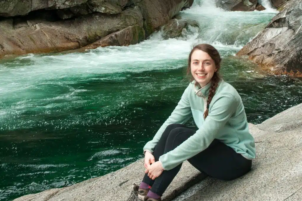


In October 2020 I paddled the Dumoine River with some friends. Our trip was four nights long and we covered 76 km in total. It was a great trip with excellent campsites, beautiful weather (and fall foliage) and a ton of awesome whitewater paddling.
If you’re thinking of paddling the Dumoine River yourself, here is a comprehensive trip report to help with your planning. In this report I cover the maps and resources, shuttle and outfitter options, put-ins and take-outs, route, campsites and more.
The Dumoine River is 1/3 of the ‘Three Sisters”, a trio of parallel rivers that flow south into the Ottawa River. I paddled the other two sisters, The Noire and The Coulonge, in 2017 and 2019, respectively. The Dumoine was my favourite of the three.
Dumoine River Trip Video
Tip! It’s taken me a while to perfect my GoPro set up. To make the battery last for all the rapids, bring a strong PowerBank and Dual Charger.
Dumoine River Maps & Resources
Now, I can’t take credit for planning our route. That goes to my canoe partner, Sandro (check him out here). However, I can tell you what maps and resources were used to plan the trip, and then navigate the river.
Topographical Maps
If you were to get the individual topographical maps, I believe these are the ones you would need:
- 31 K/13 Lac Dumoine
- 31 K/12 Lac Russel
- 31 K/5 Lac du Pinceau
- 31 K/4 Rolphton
However, there is a compilation of the river sections of topographical maps online for free on the Carte Plein Air website. It’s a PDF you can print and this is what Sandro brought on our trip.
>>Click here for map of the Dumoine River.
Guide Book
In addition to the maps, I recommend purchasing a copy of Rivers of the Upper Ottawa Valley by Hap Wilson. If you don’t know him, Hap is an accomplished paddler in Canada who hand draws all the rapids with suggestions on what lines to take.
I’ve taken “Hap’s Maps” on almost all of my trips. We typically photocopy the relevant pages and then laminate them so they’re waterproof.
>>Click Here to View Rivers of the Upper Ottawa Valley
The Dumoine River is located on the traditional territory of Omàmìwininìwag (Algonquin). The original names for the Dumoine River are Cakawitopikak Sipi and Ekonakwasi Sipi. The first name translates to Alder River, after a tree which abundantly lines the banks of the river. The second name translates to Desire River.


This post may contain affiliate links. If you make a purchase through one of these links, I may receive a small commission at no extra cost to you. Your support is much appreciated! You can learn more by reading my full disclosure.
Dumoine River Shuttle & Outfitters
Guided or Self-Guided
This river requires an intermediate level of whitewater skill. They are some tricky rapids and my group of very experienced paddlers had two tips and a few close calls. We also had to leverage some of our whitewater rescue skills to cross a rapid and unpin a canoe.
As you’ll see below, there are three days that have big rapid, after big rapid, after big rapid. All of the big rapids have portages around them, but you don’t want to be constantly portaging.
So if you don’t have the skills to do the trip self-guided, there are a few outfitters who run Dumoine River Expeditions. The ones I’m most familiar with are:
- Black Feather Outfitters
- MHO Adventures
Shuttles
Up until the last decade or two, access to the Dumoine River required a float plane to either Lac Dumoine or Lac Benoit. Thankfully, there is now road access which makes the trip considerably cheaper.
We had our shuttle done by Noel Leclerc, who is based out of Centrale des Joachims, a small village on the Quebec side of the Ottawa River. His contact information is here.

Dumoine River Canoe Route
The Dumoine River has a very standard route. There are a handful of put-ins depending on how long you want your trip to be, and the take-out is on the Ottawa River.
In this section, I’ll walk you through the route we took down the Dumoine.
Day 1: Access Road (km 64) to Canoe Eater (km 59)
For the longest length of trip, the put in is either Lac Dumoine or Lac Dix Miles. We were originally going to put in around here (specifically around km 84), but one of the roads become inaccessible so we started 20 km downriver at the end of a logging road (km 64).
Our day started with meeting Noel. We got our gear and canoes loaded onto two pickup trucks (a van and trailer wouldn’t be able to handle the logging road). It was a ~2.5 hour drive to the put-in. It was a seriously bumpy drive.
We put in at kilometre 64, at the end of a logging road. This put us directly downriver of Triple Sault, a series of 3 chutes / ledges and the portage Hap Wilson admiringly refers to as “Grunt Portage”.
From there, we had almost non-stop rapids-swifts-rapids to the first campsite.
Rapids
- Du Pont Rapids (CII)
- Rapides Crampe en Masse (CI / CII)
- Canoe Eater (CIII) – This is a tricky one, only paddle if you are experienced. Note that there is a ledge to portage / line directly after.
Campsite: Downriver to Canoe Eater
For our first night be camped at the group site right after Canoe Eater. It was a nice site, but paled in comparison to our upcoming campsites.


Day 2: Canoe Eater (km 59) to Ile Burnt (km 49)
Day 2 was a super fun day. So many fun sets of rapids to paddle! As you can see, this is not a river for novice whitewater paddlers. We had ~7 rapids with a rating of Class II or higher.
Rapids
- Sleeper Rapids (CII)
- Double Choice Rapids (CII / CIII)
- Snake Rapids (CII /CIII)
- Thread the Needle (CIII)
- Log Jam Rapids (CII / CIII)
- Gooseneck Rapids (CII)
- Little Steel Rapids (CI – CII)
- Little Steel Falls – This is a CIV and should definitely be portaged.
- Cliff Hanger Rapids (CII)
Campsite: “Ile Burnt”
This was the best campsite we stayed at. Actually, it’s probably in the top ten best campsites I’ve stayed at. I may be a tad biased because we had an amazingly clear night, so I could try photographing stars, and we had a gorgeous sunrise too.
Caution! Burnt Island is beautiful, but it is a small island and there is no place to poop. As such, whenever someone had to go, they solo paddled to the river left campsite and used the Thunderbox there.


Day 3: Ile Burnt (km 49) to Grand Chute (km 22)
Our third day had a few decently sized rapids, but the main event was Grand Chute. If there is ever a time to hug the shoreline and cautiously approach a portage, it is here!
Rapids
- Big Steel (CII / CIII)
- Horse Race (CII)
- Z Rapids (CII)
- Tucker Rapids (CII / CIII)
Big Portage: Grand Chute
Our most daunting task of the day was a 1300 m portage around Grand Chute. For the first trip, we followed the trail with our gear to the second campsite. The trail was very rugged and portaging with a canoe would have been difficult.
So for the second trip with the canoes, we didn’t follow the trail. Instead, we went up the road a bit and then turned onto an ATV trail. This made the portage a little longer than 1300 m, but the ATV trail was wide, very flat and had no obstacles. I recommend taking this route.
Campsite: “Grand Chute”
Grand Chute was another excellent campsite. There are two campsites here; we stayed at the one slightly downriver because it was a lot bigger.
Even though it was mid-October, I actually did go for a quick swim at this campsite. There is a large eddy protected by some rocks adjacent to the campsite.
Caution! Don’t be deceived by the small rapids in the photos below. The top part of Grand Chute is a roaring madness, I just didn’t get a good pic of it.


Day 4: Grand Chute (km 22) to Campsite at km 8
We had our last two rapids on this day. Walrus Rapids was a short and easy one. Red Pine Rapids, on the other hand, was a kilometre of alternating Class II and Class III rapids. Pay attention to the map and the water in front of you; there is a ledge you’ll need to portage / line.
Rapids
- Walrus Rapids (CI / CII)
- Red Pine Rapids (CIII)
Campsite: Group campsite at km 8
This was a great campsite. It was a good size for our group and had plenty of good tent spots. Although it didn’t have the same views as Ile Burnt and Grand Chute, we did get the best sunset of the entire trip here.


Day 5: Campsite at Km 8 to Take Out
Between our campsite and the takeout, we had 8 km of paddling on the Dumoine and 12 km of paddling on the Ottawa River. There were no rapids in this section, however, there was one quick portage around a beautiful chute (the most beautiful one of the trip, in my opinion).
Portage
Chute Ryan
Take Out
According to the trip reports I read, the most common place to take out is Driftwood Provincial Park, which is on the south side of the Ottawa River, a little east of the mouth of the Dumoine River.
We, on the other hand, took out at the portage near Centrale des Joachims. You’ll see on the map that the Ottawa River splits in two sections and both sections result in a damn. We took out on the left shore of the river right section, and there’s a huge yellow portage sign to indicate it.


Dumoine River – Final Thoughts
Out of the Three Sisters, the Dumoine was definitely my favourite river. It had the best campsites (no sand!) and easily the best whitewater. I also preferred it to the Petawawa, which I paddled earlier this summer, because the Dumoine had much longer rapids sets and more swifts. We did have unusually high water for the Dumoine, but I think I’d prefer it at any water level.
Overall, if you’re thinking of paddling the Dumoine River, grab yourself a copy of Rivers of the Upper Ottawa Valley, call your paddling mates and get to planning. This is a classic effort well worthy of the hype.
Pin for Later!


Stay in Touch
Join our community of outdoor adventurers - you'll find trip inspiration, gear discussions, route recommendations, new friends and more!
Greatly enjoyed your Dumoine video.
What was the cfs?
I’m not sure actually! I recall everyone saying it was mid-high water (my friends paddled it just a couple weeks before it was really low for them – but we paddled it after a stretch of heavy rain)
Wow! Looks amazing. Definitely going to try to convince my canoeing partners to go there next year. Your video and description are excellent and very useful. Keep up the great work.
Question: do you know anyone that offers whitewater canoeing lessons? I’m great in a canoe but I’m missing some Whitewater experience. We did the Petawawa twice and la noire.
Yes I do! Paddler Coop and Madawaska Kanu both offer whitewater paddling lessons. I believe Boreal River Rescue does as well. All of them are located around the Ottawa Valley area. And thanks so much – glad you found them helpful!
Question re: poop. Are there places along the way for bathroom or are you carrying it out? Thanks!!
Each of the campsites had a Thunderbox (except the island site, but you can paddle across to the campsite on the river bank and there is a thunderbox there). No need to pack out poop!