
The Ontario backpacking scene doesn’t get nearly the same appreciation as that of Alberta or British Columbia. It’s true that Ontario doesn’t have nearly as many trails as the other two provinces, however, what we lack in quantity we make up for in quality: there are some incredible backpacking trails in Ontario.
So if you’re looking to level up your hiking or escape the crowds by getting further into the backcountry, you’ve come to the right place. In this post, I’ll go over 10 different backpacking trails in Ontario.
I’ve included the distance and difficulty, as well as how many days people typically take to complete it. Many of the routes have accompanying trip reports on Trip Reports and have been linked.
At the end of the post, I go over some tips for backpacking in Ontario – safety, bears, trekking poles, reservations and more. I hope you find this helpful!
Ontario Backpacking Trails: Map
Backpacking Trails in Ontario: Quick Summary
These are the backpacking trails covered in the post.
| Name | Park | Distance | Days | Difficulty | Trip Report |
|---|---|---|---|---|---|
| Bruce | Bruce Peninsula NP | 12 – 21 km | 1 – 3 | Beginner | Click Here |
| Eastern Pines | Algonquin PP | 6 – 15 km | 2 – 3 | Beginner | Coming Soon |
| Highland | Algonquin PP | 19 – 35 km | 2 – 3 | Beginner | Click Here |
| MacKenzie | Mississagi PP | 22 km | 2 – 3 | Intermediate | Coming June |
| Kabeyun | Sleeping Giant PP | 37 km | 4 – 5 | Intermediate | Click Here |
| Western Uplands | Algonquin PP | 33 – 88 km | 3 – 6 | Intermediate | Click Here |
| Casque Iles | Lake Superior NMCA | 53 km | 3 – 5 | Intermediate | Coming Soon |
| La Cloche-Silhouette | Killarney PP | 78 km | 7 – 10 | Advanced | Click Here |
| Coastal | Pukaskwa NP | 60 km | 5 – 6 | Advanced | Click Here |
| Coastal | Lake Superior PP | 65 km | 5 – 6 | Advanced | Click Here |
This post may contain affiliate links. If you make a purchase through one of these links, I may receive a small commission at no extra cost to you. Your support is much appreciated! You can learn more by reading my full disclosure.
10 Backpacking Trails in Ontario
Okay, without further ado, here are the 10 best backpacking trails in Ontario. I’ve ordered them by difficulty, with the easy trails first and then progressively getting more challenging.


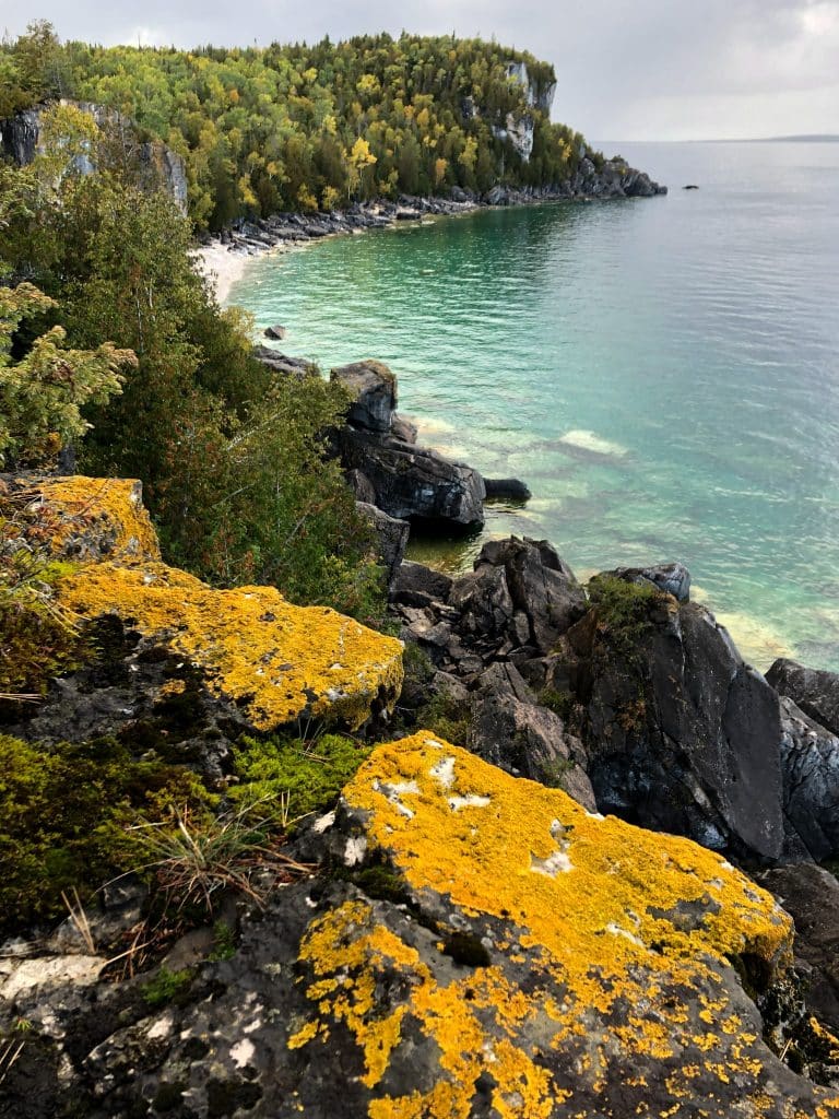
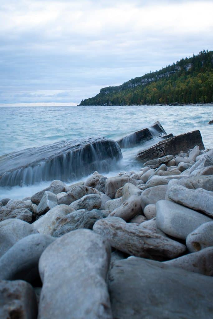
Bruce Trail – Bruce Peninsula National Park
The Bruce Trail is one of the longest backpacking trails in Ontario, covering over 100 km long and stretching from the Niagara Escarpment to Bruce Peninsula. I’ve hiked the section in Bruce Peninsula National Park and it quickly became one of my favourite areas in Ontario. The sheer cliffs drop dramatically into the tropical-looking water of Georgian Bay.
There are a few options for routes, depending on how much time you have. For a single night, you can hike to one of the two backpacking campgrounds, Stormhaven or High Dump, and return the way you came.
For a longer trip, you could visit both campsites and the Grotto, which would end up being a total of about 21 km. There’s some debate on which campground is better – I stayed at High Dump and briefly visited the more popular Stormhaven – and my recommendation is definitely High Dump (less visited, wilder).
Quick Facts:
- Type: There-And-Back
- Distance: 8 – 21 km
- Trip Length: 2 – 4 days
- Difficulty: Beginner
Read the full Bruce Trail – BPNP guide here


Eastern Pines – Algonquin Provincial Park
Eastern Pines is Algonquin’s shortest backpacking trail and is a great option for novice backpackers. It begins near Achray Campground, on the east side of the park. From there, there are two loops. One is around Berm and Johnston Lake (6 km loop). The other is around Berm, Johnston and Bulcholtz lakes with stops at Stratton Lake and High Falls Bay (15 km loop). I haven’t been on this trail myself, but I’ve heard that Stratton Lake is very nice, as is High Falls Bay.
This would be a great introduction trail for novice backpackers – even the longer loop only has 400 m of elevation gain on the entire trail. This means relatively few steep sections. For reference, the more popular Highland Backpacking Trail in Algonquin (see below) has 1500 m of elevation gain.
As this trail is in Algonquin Provincial Park, you will need to make campsite reservations in advance. A reservation secures a campsite on a particular lake, thought the actual campsite is first-come-first-serve.
Quick Facts:
- Type: Loop
- Distance: 6 – 15 km
- Trip Length: 2 days
- Difficulty: Beginner
Read More: 22 Best Ontario Provincial Parks for Camping, Hiking and Paddling
Highland Backpacking Trail – Algonquin Provincial Park
The Highland Backpacking Trail is one of the best beginner backpacking trails in Ontario. There are two route options, depending on your skill level. The first is a 19 km loop around Provoking Lake. The terrain is very flat and the trail is easy to navigate.
The second option adds on a detour from Provoking Lake to Head and Harness Lake. There is much more elevation gain on this route; it’s still suitable for beginners if you have a good level of fitness and experience doing long day hikes.
The campsites are all really nice and can be booked through Ontario Parks. Although a straightforward trail, there are some things to be mindful of, specifically in regards to bear safety, mosquitoes and trekking poles, so I recommend reading the guide linked below.
Quick Facts:
- Type: Loop
- Distance: 19 / 35 km
- Trip Length: 2 – 3 days
- Difficulty: Beginner
Read the full Highland Backpacking Trail here.


MacKenzie Trail – Mississagi Provincial Park
Misssissagi Provincial Park is definitely a hidden gem; not many people have heard of the park, let alone explored it. The park is located in Algoma County, northwest of Killarney Provincial Park. The park isn’t super big, however there are a few day hikes in the park and one backpacking trail for those wanting to stay in the park overnight.
Over 22 km, the MacKenzie Trail passes through a variety of landscapes; you’ll see pine and maple trees, exposed granite and quartz rock and crystal clear lakes. The highlight of the trip is the eastern section, which offers views of Stag Lake Peatlands (an ecologically significant wetland). Another excellent lookout point is the one overlooking Brush Lakes or one over a small canyon.
The trail has two campgrounds – one at Brush Lakes and another at Helenbar Lake. When making your campsite reservation, you simply book for a backcountry site. You then can camp at any campsite in the park.
- Type: Loop
- Distance: 22 km
- Trip Length: 2 days
- Difficulty: Beginner
Kabeyun Trail – Sleeping Giant Provincial Park
The Kabeyun Trail is a fantastic backpacking trail in Ontario. Located in Sleeping Giant Provincial Park, on the northern shores of Lake Superior, the Kabeyun offers rocky terrain and incredible views of the seemingly endless lake.
The trail itself is only 27 km, but there are 8 km worth of additional side trails that lead to excellent views – like the Top of the Giant and the Chest. If you’re used to hiking in southern Ontario, those distances won’t seem like much. But remember that the trails in northern Ontario are much more rugged and take more time to hike.
July is the most popular time to do the hike, but ensure you bring bug spray and bug jackets, as the mosquitos can be absolutely brutal. Also, beware that the water in Lake Superior is always cold – you can swim, but bring a towel and have a fire at the ready.
Quick Facts:
- Type: Loop
- Distance: 27 km
- Trip Length: 3-4 days
- Difficulty: Beginner
Read the full Kabeyun Trail guide here.


Western Uplands – Algonquin Provincial Park
This is the longest backpacking trail in Algonquin and a less popular option in comparison to Highland Backpacking Trail. Located in the southwest corner of the park, this is also an accessible hiking trail for those arriving from Toronto – it’s just past the West Gate on Highway 60. The Western Uplands Backpacking Trail can be as short as 32 km and as long as 88 km – though I’ve heard that the trail on the longer loop is quite overgrown and difficult to navigate.
That said, the Western Uplands also offers some degree of route choice – something the other two Algonquin backpacking trails lack. For example, you could add on a few kilometres and circumnavigate Maggie Lake. Or, you could shorten the longest route by detouring to West Otterpaw Lake or Eu Lake. Likewise, the final stretch to McCraney Lake is entirely optional.
Quick Facts:
- Type: Loop
- Distance: 32 – 88 km
- Trip Length: 3 – 6 days
- Difficulty: Moderate


Read More: 11 Algonquin Park Campgrounds: A Helpful Guide to Camping in Algonquin
Casque Isles Trail – Lake Superior National Marine Conservation Area
Casque Isles is our second Ontario backpacking trail on Lake Superior. The trail begins in Rossport, about halfway in between Thunder Bay and Marathon, just off of Highway 17. The trail connects three towns – Terrance Bay, Schreiber (where my mom grew up!) and Rossport, and it is an important section of the Voyageur Hiking Trail.
One of the nice things about the Casque Isles Trail is that it doesn’t require campsite reservations or permits. So if you were planning to hike the coastal trails in Pukaskwa National Park or Lake Superior National Park, but weren’t able to land campsite reservations, the Casque Isles is a nice alternative.
- Type: Thru-Hike
- Distance: 53 km
- Trip Length: 3 – 5 days
- Difficulty: Moderate
La Cloche-Silhouette Trail – Killarney Provincial Park
The La Cloche-Silhouette trail is probably the most popular backpacking trail in Ontario. This is an ~80 km trail that loops around the entirety of Killarney Provincial Park, passing through gorgeous blue lakes, granite ridgelines and tons of fantastic viewpoints.
While Ontario backpacking trails don’t exactly have a reputation for difficulty, the nearly 2000 m of elevation gain over the La Cloche will push your limits. Experienced hikers with excellent fitness can get the trail done in as little as four days, though the park generally recommends the average backpacker take between 7 and 10 days to complete the loop
But the most difficult part of hiking this trail is just getting a reservation. There are only about 60 campsites along the entire trail, reservable 5 months in advance. You should plan to book your campsites the very first day they become available.
Quick Facts:
- Type: Loop
- Distance: 78 km
- Trip Length: 4 – 10 days
- Difficulty: Advanced
Read the full La Cloche guide here.


Coastal Trail – Pukaskwa National Park
Pukaskwa National Park is located on the northern shores of Lake Superior, just south of Marathon. The park is known for its coastal canoeing and sea kayaking, in addition to its highly regarded Coastal Trail. The trail traces the coastline from Hattie Cove to North Swallow River, making a slight deviation from the coastline to go around Chigaamiwinigum Falls and Hook Falls. One of the best views of the hike is Willow River.
The trail is 60 km long and you should be humble about how much distance you can cover each day, especially if you’re accustomed to hiking backpacking trails in southern Ontario. This is a difficult hike. It’s also quite remote, so help will not be immediately available if you run into trouble – ensure you have the experience required for a route of this level.
Parks Canada recommends taking a boat shuttle from Hattie Cove to North Swallow River and then hiking north back to Hattie Cove. If you didn’t want to organize a shuttle, you could do the hike as an out and back trip (i.e. hiking Hattie Cove to Fish Harbour and then going back to Hattie Cove over 3 – 4 days).
- Type: Thru-Hike
- Distance: 60 km
- Trip Length: 5 – 7 days
- Difficulty: Hard
Check out the trip report here!


Coastal Trail – Lake Superior Provincial Park
The Coastal Trail is a spectacular backpacking trail in northern Ontario. Over 65 km, the route traces the rugged coastline of Lake Superior and features granite outcrops, pebble bars and sandy beaches.
Despite the park’s isolation and distance from major towns, the trail does have a tendency to get busy in the summers – although nowhere near the likes of southern parks such as Algonquin or Killarney. Regardless, campsite reservations are required and expect to see other groups on the trail.
The terrain is not for the faint of heart; this is a difficult backpacking trail and much more challenging than those in southern Ontario. The trail itself is much more rugged and less groomed, the elevation gains and descents are plentiful, and the exposed moss-covered rocks get extremely slippery when wet.
Quick Facts:
- Type: Thru-Hike
- Distance: 65 km
- Trip Length: 5 – 7 days
- Difficulty: Hard
Read the full Coastal Trail guide here


Backpacking Ontario: Important Things to Know
Emergency Communication Device
Many of the backpacking trails in Ontario are outside the reaches of cell service, so it’s important to carry an emergency communication device in case you run into trouble.
There are a few options depending on how much functionality you need. I asked the members of my Facebook Group what device they preferred and here were the top recommendations:
- Garmin inReach or Garmin inReach Mini – Operates on the highly reliable Iridium network. Although pricey, the Garmin inReach allows for two-way voice and messaging communication and has a map display.
- Zoleo – Also on the Iridium network, this satellite communication device connects to your Smartphone, allowing you to send and receive messages.
- SPOT – Although a few use it, a lot of my members of my Facebook Group find the SPOT less reliable and not as feature-rich as the two options above.
Bears in Ontario
Each provincial and national park has its own recommendations for dealing with bears in their park.
In Bruce Peninsula National Park, for example, both of the backcountry campgrounds have a metal structure for doing bear hangs. In Algonquin Provincial Park, on the other hand, you’re expected to do your own bear hang.
I suggest checking out the recommendations for the specific park you’ll be camping in, and if you need a little more guidance, check out the blog post below.
Read More: How to Bear-Proof Your Campsite and Protect Against Black Bears in Ontario
Trekking Poles
Trekking poles are helpful on long, overnight hikes for a few reasons. For starters, they help with stabilization when you’re walking on uneven terrain. And when you’ve got a heavy backpack on and your centre of gravity is skewed, the added stabilization can be really helpful.
Second, they help relieve stress on your knees on steep descents. This may be surprising, but your knees actually have a much harder time going down than they do going up. If you have bad knees (like me), trekking poles will make a huge difference.
Finally, trekking poles help you stay upright while hiking. With a heavy backpack on, we have a tendency to bend forward at the hips or hunch our shoulders. This strain adds up over the miles and can leave you feeling sore and stiff.
That said, the use of trekking poles tends to be a personal decision. Some people prefer to have use of their hands while hiking. If you’ve done lots of long hiking trails in Ontario before, you probably already know your preferences.
However, if this is your first time on one of the overnight hiking trails in Ontario you likely don’t know your preferences yet. In that case, I recommend bringing trekking poles. You can always store them in your backpack if you decide you don’t want them.
Read More: Do I Need Trekking Poles? (Coming Soon)
Common Injuries on the Trail
In my backpacking experience, I’ve come to recognize a few common injuries. After speaking with my friends who have hiked various overnight hiking trails in Ontario, the common injuries held true. Here are some things to be mindful of on the trail – and always bring a full wilderness first aid kit to help you deal with them.
- Scrapes and cuts from falling on slippery rocks – This was especially -prevalent on the coastal hiking trails, where rugged, moss-covered rocks make up a lot of the trail and are terribly slippery when wet. Bring some bandages and Polysporin.
- Rolled / sprained ankles – I can personally attest to this one, as I’m sprained my ankle twice on backpacking trips. Ensure you wear sturdy hiking shoes with good grips and be careful on slippery sections. Bring a tensor bandage, an instant icepack and some ibuprofen.
- Aches and pains, especially in the back and shoulders – Carrying a large, heavy backpack for long distances will take its toll on you. While little can be done to prevent this (besides packing light, using a backpack with a good harness and walking with good posture), it helps to have some pain medication or muscle-soothing lotion.
- Bug bites – Beware that many trails will have lots of mosquitos and black flies – especially if you’re hiking between May and July. Bring a bug hat / bug jacket, some bug cream for your hands and some Benadryl (in case you get lots of bites that swell). A little calamine lotion can help too.
Read More: How to Build Your Own Wilderness First Aid Kit
Reservations
The majority of trails on this list require some sort of reservation – either for the specific campsites, the general area of campsites or to be on the trail in general.
Many of the trails are also very popular and the available number of permits is kept low to ensure environmental conservation and an enjoyable trail experience. This means you should book your trip early.
Ontario Backpacking Trails: Final Thoughts
This post introduced you to 10 excellent Ontario backpacking trails – and I hope at least of few of them have piqued your interest.
If you want detailed trip reports on any of the routes above, be sure to check out Trip Reports, which is a growing collection of backcountry hiking and canoeing routes across Canada!
MY FAVOURITE GEAR
Fleece Sweater
Down Jacket
Hiking Boots
Hiking Shirt
Back Pack
Hiking Pants